Price search results for Maps Ti00000857 Apache Creek And Juniper Mesa Wilderness Areas Prescott And Kaibab National Forests Map
⇑ click on img to enlarge
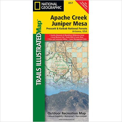
Maps Ti00000857 Apache Creek And Juniper Mesa Wilderness Areas Prescott And Kaibab
Apache Creek/juniper Mesa Trails Illustrated Topographic Map Is The Most Comprehensive Available For Outdoor Enthusiasts Of All Types. Designed To Be Easy-to-read, Yet Highly Detailed This Map Includes A Comprehensive Road And Trail Network Distinguishing Between Major, Secondary, High-clearance, Hiking, Motorized And Non-motorized Trails. All Forest Roads Are Labeled With Their Official Road Number And Trails Are Clearly Identified With Their Given Name. Boundaries Are Color-coded And Clearly Shown For National Forest, Ranger Districts, Wilderness Areas, County/regional Parks, And State Wildlife Areas. Additionally, Arizona Game Management Unit (gmu) Boundaries And Public And Private Lands Are Clearly Identified. An Extensive Collection Of Important And Unique Locations Are Pinpointed On The Map Including: Ranger Districts, Campgrounds, Picnic Facilities, Trailheads, Gates, Boat Launches, Atv Trails, Motorcycle Trails, Shooting Ranges, And Recreation Sites With Universal Access Capabilities. Every National Geographic Trails Illustrated Map Is An Essential Tool For Safely Navigating The Backcountry With Gps Or Compass As They Are Clearly Marked With Compass Rose With Magnetic Declination, Scale Bar, And Full Legend. Some Of The Places Shown On The East Side Of The Apache Creek/juniper Mesa Map Include: Prescott National Forest, Verde River, Woodchute Wilderness, Great Western Trail, Mingus Mountain, Alto Pit Ohv Area, Granite Mountain Wilderness, Upper Verde River State Wildlife Area, And More. The West Side Of The Map Features: Prescott National Forest, Apache Creek Wilderness, Juniper Mesa Wilderness, And Extensive Ohv Trails Near Denny, Stinson, And Cottonwood Mountains. The Map Is Two-sided. Apache Creek And Juniper Mesa Adjoins Our Sycamore Canyon Map To The East And Our Bradshaw Mountains Map To The South.printed On Waterproof Material.tear Resistant.stands Up To The Rigors Of Travel.includes Utm Grids For Use With Your Gps Unit.contour Interval: 50'.scale 1:70,000 (1 1.1 Mile).folded Size: 4.25" H X 9.25" W.made In Usa.dimensions: 26" H X 38" W.
Add to Shopping List
Maps Ti00000857 Apache Creek And Juniper Mesa Wilderness Areas Prescott And Kaibab National Forests Map Prices
The best price found is $18.20 from Unbeatable Sale.
| Where to buy | Price | Visit Store |
|---|---|---|
|
|
$18.20 | Visit Store |
